|
|
|||||||||||||||||
| Point ID: 6911 | Downloads | Plots | Site Data | Code: 10573 |
|
|
|||||||||||||||||
| Download | |
|---|---|
| Site Descriptor Information | Site Time Series Data |
| Link to all available data | |
| View: | Time Series | All |
| Units: | m3/s |
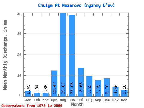
| Statistic | Jan | Feb | Mar | Apr | May | Jun | Jul | Aug | Sep | Oct | Nov | Dec | Annual |
|---|---|---|---|---|---|---|---|---|---|---|---|---|---|
| Mean | 2.45 | 1.86 | 1.85 | 12.47 | 39.86 | 39.06 | 13.66 | 9.62 | 7.75 | 8.70 | 4.56 | 3.18 | 144.69 |
| Standard Deviation | 0.62 | 0.47 | 0.48 | 5.75 | 8.74 | 12.26 | 5.01 | 3.58 | 3.02 | 4.65 | 1.75 | 1.04 | 27.75 |
| Min | 1.74 | 1.11 | 1.23 | 5.10 | 23.08 | 19.81 | 7.24 | 3.49 | 2.50 | 3.46 | 2.27 | 1.47 | 102.74 |
| Max | 3.42 | 2.88 | 3.06 | 24.55 | 61.51 | 61.85 | 24.82 | 16.87 | 12.75 | 22.53 | 7.74 | 5.15 | 206.19 |
| Coefficient of Variation | 0.25 | 0.26 | 0.26 | 0.46 | 0.22 | 0.31 | 0.37 | 0.37 | 0.39 | 0.54 | 0.38 | 0.33 | 0.19 |
 Return to R-Arctic Net Home Page