|
|
|||||||||||||||||
| Point ID: 6907 | Downloads | Plots | Site Data | Code: 10568 |
|
|
|||||||||||||||||
| Download | |
|---|---|
| Site Descriptor Information | Site Time Series Data |
| Link to all available data | |
| View: | Time Series | All |
| Units: | mm |
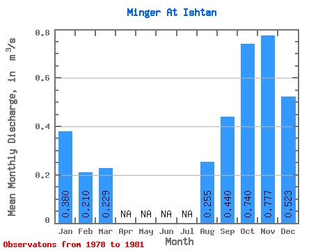
| Statistic | Jan | Feb | Mar | Apr | May | Jun | Jul | Aug | Sep | Oct | Nov | Dec | Annual |
|---|---|---|---|---|---|---|---|---|---|---|---|---|---|
| Mean | 0.38 | 0.21 | 0.23 | 0.26 | 0.44 | 0.74 | 0.78 | 0.52 | |||||
| Standard Deviation | 0.16 | 0.11 | 0.12 | 0.12 | 0.29 | 0.42 | 0.37 | 0.01 | |||||
| Min | 0.21 | 0.13 | 0.10 | 0.17 | 0.11 | 0.25 | 0.36 | 0.51 | |||||
| Max | 0.53 | 0.34 | 0.31 | 0.34 | 0.61 | 0.99 | 1.05 | 0.54 | |||||
| Coefficient of Variation | 0.42 | 0.54 | 0.50 | 0.47 | 0.65 | 0.57 | 0.47 | 0.03 |
 Return to R-Arctic Net Home Page