|
|
|||||||||||||||||
| Point ID: 6907 | Downloads | Plots | Site Data | Code: 10568 |
|
|
|||||||||||||||||
| Download | |
|---|---|
| Site Descriptor Information | Site Time Series Data |
| Link to all available data | |
| View: | Time Series | All |
| Units: | m3/s |
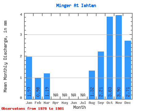
| Statistic | Jan | Feb | Mar | Apr | May | Jun | Jul | Aug | Sep | Oct | Nov | Dec | Annual |
|---|---|---|---|---|---|---|---|---|---|---|---|---|---|
| Mean | 1.97 | 0.99 | 1.19 | 1.32 | 2.21 | 3.83 | 3.89 | 2.71 | |||||
| Standard Deviation | 0.83 | 0.54 | 0.59 | 0.62 | 1.43 | 2.20 | 1.84 | 0.08 | |||||
| Min | 1.09 | 0.61 | 0.51 | 0.88 | 0.55 | 1.29 | 1.81 | 2.64 | |||||
| Max | 2.75 | 1.60 | 1.61 | 1.76 | 3.06 | 5.13 | 5.26 | 2.80 | |||||
| Coefficient of Variation | 0.42 | 0.54 | 0.50 | 0.47 | 0.65 | 0.57 | 0.47 | 0.03 |
 Return to R-Arctic Net Home Page