|
|
|||||||||||||||||
| Point ID: 6901 | Downloads | Plots | Site Data | Code: 10558 |
|
|
|||||||||||||||||
| Download | |
|---|---|
| Site Descriptor Information | Site Time Series Data |
| Link to all available data | |
| View: | Time Series | All |
| Units: | mm |
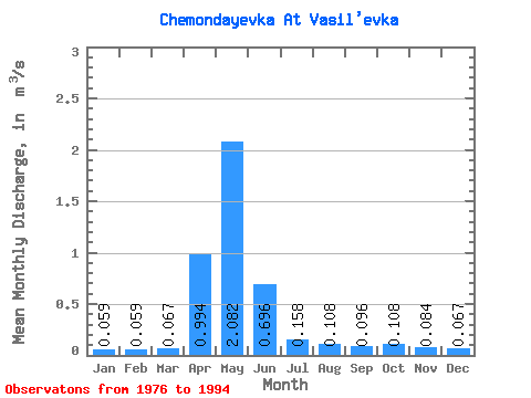
| Statistic | Jan | Feb | Mar | Apr | May | Jun | Jul | Aug | Sep | Oct | Nov | Dec | Annual |
|---|---|---|---|---|---|---|---|---|---|---|---|---|---|
| Mean | 0.06 | 0.06 | 0.07 | 0.99 | 2.08 | 0.70 | 0.16 | 0.11 | 0.10 | 0.11 | 0.08 | 0.07 | 0.38 |
| Standard Deviation | 0.01 | 0.02 | 0.01 | 0.93 | 1.81 | 1.12 | 0.18 | 0.07 | 0.04 | 0.04 | 0.02 | 0.02 | 0.29 |
| Min | 0.03 | 0.04 | 0.04 | 0.06 | 0.36 | 0.11 | 0.03 | 0.03 | 0.04 | 0.04 | 0.05 | 0.03 | 0.17 |
| Max | 0.08 | 0.10 | 0.09 | 3.16 | 7.16 | 4.81 | 0.73 | 0.28 | 0.18 | 0.20 | 0.11 | 0.10 | 1.40 |
| Coefficient of Variation | 0.23 | 0.28 | 0.22 | 0.93 | 0.87 | 1.60 | 1.15 | 0.62 | 0.40 | 0.40 | 0.21 | 0.25 | 0.76 |
 Return to R-Arctic Net Home Page