|
|
|||||||||||||||||
| Point ID: 6901 | Downloads | Plots | Site Data | Code: 10558 |
|
|
|||||||||||||||||
| Download | |
|---|---|
| Site Descriptor Information | Site Time Series Data |
| Link to all available data | |
| View: | Time Series | All |
| Units: | m3/s |
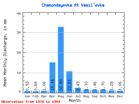
| Statistic | Jan | Feb | Mar | Apr | May | Jun | Jul | Aug | Sep | Oct | Nov | Dec | Annual |
|---|---|---|---|---|---|---|---|---|---|---|---|---|---|
| Mean | 0.92 | 0.85 | 1.05 | 15.16 | 32.79 | 10.61 | 2.48 | 1.70 | 1.47 | 1.70 | 1.28 | 1.05 | 70.85 |
| Standard Deviation | 0.21 | 0.24 | 0.23 | 14.10 | 28.59 | 17.02 | 2.85 | 1.06 | 0.59 | 0.68 | 0.27 | 0.26 | 53.99 |
| Min | 0.49 | 0.53 | 0.63 | 0.90 | 5.67 | 1.68 | 0.50 | 0.50 | 0.59 | 0.58 | 0.72 | 0.54 | 32.19 |
| Max | 1.31 | 1.44 | 1.35 | 48.18 | 112.79 | 73.34 | 11.50 | 4.41 | 2.74 | 3.15 | 1.68 | 1.56 | 259.47 |
| Coefficient of Variation | 0.23 | 0.28 | 0.22 | 0.93 | 0.87 | 1.60 | 1.15 | 0.62 | 0.40 | 0.40 | 0.21 | 0.25 | 0.76 |
 Return to R-Arctic Net Home Page