|
|
|||||||||||||||||
| Point ID: 6900 | Downloads | Plots | Site Data | Code: 10556 |
|
|
|||||||||||||||||
| Download | |
|---|---|
| Site Descriptor Information | Site Time Series Data |
| Link to all available data | |
| View: | Time Series | All |
| Units: | mm |
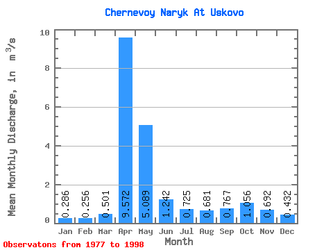
| Statistic | Jan | Feb | Mar | Apr | May | Jun | Jul | Aug | Sep | Oct | Nov | Dec | Annual |
|---|---|---|---|---|---|---|---|---|---|---|---|---|---|
| Mean | 0.29 | 0.26 | 0.50 | 9.57 | 5.09 | 1.24 | 0.72 | 0.68 | 0.77 | 1.06 | 0.69 | 0.43 | 1.76 |
| Standard Deviation | 0.12 | 0.10 | 0.42 | 3.24 | 3.62 | 0.64 | 0.33 | 0.30 | 0.43 | 0.63 | 0.31 | 0.24 | 0.39 |
| Min | 0.03 | 0.11 | 0.12 | 5.03 | 1.45 | 0.47 | 0.34 | 0.20 | 0.16 | 0.32 | 0.28 | 0.22 | 1.14 |
| Max | 0.47 | 0.46 | 1.99 | 15.00 | 15.30 | 2.78 | 1.63 | 1.44 | 1.75 | 2.86 | 1.24 | 1.27 | 2.51 |
| Coefficient of Variation | 0.41 | 0.37 | 0.84 | 0.34 | 0.71 | 0.52 | 0.45 | 0.44 | 0.56 | 0.59 | 0.44 | 0.56 | 0.22 |
 Return to R-Arctic Net Home Page