|
|
|||||||||||||||||
| Point ID: 6900 | Downloads | Plots | Site Data | Code: 10556 |
|
|
|||||||||||||||||
| Download | |
|---|---|
| Site Descriptor Information | Site Time Series Data |
| Link to all available data | |
| View: | Time Series | All |
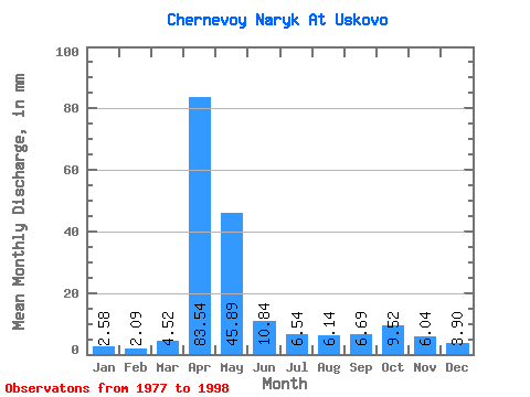
| Units: | m3/s |
| Statistic | Jan | Feb | Mar | Apr | May | Jun | Jul | Aug | Sep | Oct | Nov | Dec | Annual |
|---|---|---|---|---|---|---|---|---|---|---|---|---|---|
| Mean | 2.58 | 2.11 | 4.52 | 83.54 | 45.89 | 10.84 | 6.54 | 6.14 | 6.69 | 9.52 | 6.04 | 3.90 | 186.99 |
| Standard Deviation | 1.07 | 0.78 | 3.78 | 28.26 | 32.69 | 5.61 | 2.93 | 2.71 | 3.73 | 5.66 | 2.68 | 2.16 | 41.77 |
| Min | 0.27 | 0.90 | 1.08 | 43.90 | 13.07 | 4.10 | 3.07 | 1.80 | 1.40 | 2.88 | 2.44 | 1.98 | 120.70 |
| Max | 4.24 | 3.78 | 17.94 | 130.91 | 137.96 | 24.26 | 14.70 | 12.98 | 15.27 | 25.79 | 10.82 | 11.45 | 266.37 |
| Coefficient of Variation | 0.41 | 0.37 | 0.84 | 0.34 | 0.71 | 0.52 | 0.45 | 0.44 | 0.56 | 0.59 | 0.44 | 0.56 | 0.22 |
 Return to R-Arctic Net Home Page