|
|
|||||||||||||||||
| Point ID: 690 | Downloads | Plots | Site Data | Code: 07CA012 |
|
|
|||||||||||||||||
| Download | |
|---|---|
| Site Descriptor Information | Site Time Series Data |
| Link to all available data | |
| View: | Time Series | All |
| Units: | mm |
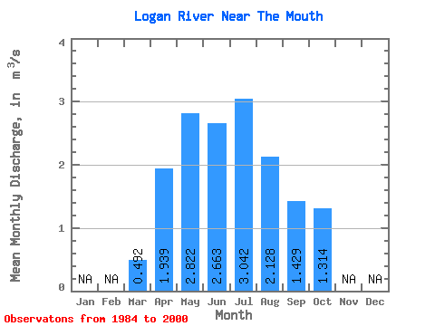
| Statistic | Jan | Feb | Mar | Apr | May | Jun | Jul | Aug | Sep | Oct | Nov | Dec | Annual |
|---|---|---|---|---|---|---|---|---|---|---|---|---|---|
| Mean | 0.49 | 1.94 | 2.82 | 2.66 | 3.04 | 2.13 | 1.43 | 1.31 | |||||
| Standard Deviation | 0.10 | 0.81 | 2.76 | 2.46 | 2.80 | 1.93 | 1.01 | 0.81 | |||||
| Min | 0.30 | 1.12 | 1.00 | 0.97 | 0.55 | 0.39 | 0.52 | 0.66 | |||||
| Max | 0.64 | 3.76 | 12.20 | 11.40 | 10.60 | 7.05 | 4.32 | 3.90 | |||||
| Coefficient of Variation | 0.20 | 0.42 | 0.98 | 0.92 | 0.92 | 0.91 | 0.71 | 0.62 |
 Return to R-Arctic Net Home Page