|
|
|||||||||||||||||
| Point ID: 690 | Downloads | Plots | Site Data | Code: 07CA012 |
|
|
|||||||||||||||||
| Download | |
|---|---|
| Site Descriptor Information | Site Time Series Data |
| Link to all available data | |
| View: | Time Series | All |
| Units: | m3/s |
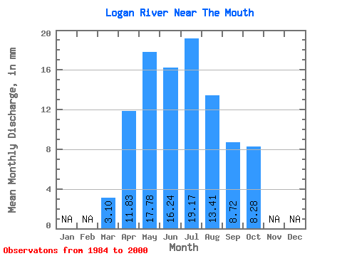
| Statistic | Jan | Feb | Mar | Apr | May | Jun | Jul | Aug | Sep | Oct | Nov | Dec | Annual |
|---|---|---|---|---|---|---|---|---|---|---|---|---|---|
| Mean | 3.10 | 11.82 | 17.78 | 16.24 | 19.17 | 13.41 | 8.72 | 8.28 | |||||
| Standard Deviation | 0.63 | 4.96 | 17.40 | 14.98 | 17.64 | 12.13 | 6.18 | 5.10 | |||||
| Min | 1.88 | 6.83 | 6.29 | 5.92 | 3.49 | 2.47 | 3.17 | 4.15 | |||||
| Max | 4.05 | 22.93 | 76.87 | 69.53 | 66.79 | 44.42 | 26.35 | 24.57 | |||||
| Coefficient of Variation | 0.20 | 0.42 | 0.98 | 0.92 | 0.92 | 0.91 | 0.71 | 0.62 |
 Return to R-Arctic Net Home Page