|
|
|||||||||||||||||
| Point ID: 6897 | Downloads | Plots | Site Data | Code: 10553 |
|
|
|||||||||||||||||
| Download | |
|---|---|
| Site Descriptor Information | Site Time Series Data |
| Link to all available data | |
| View: | Time Series | All |
| Units: | mm |
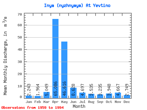
| Statistic | Jan | Feb | Mar | Apr | May | Jun | Jul | Aug | Sep | Oct | Nov | Dec | Annual |
|---|---|---|---|---|---|---|---|---|---|---|---|---|---|
| Mean | 2.24 | 1.96 | 5.05 | 65.09 | 46.62 | 8.63 | 4.70 | 3.54 | 3.23 | 3.95 | 4.67 | 2.75 | 12.89 |
| Standard Deviation | 1.34 | 1.16 | 5.50 | 34.80 | 55.02 | 7.26 | 3.59 | 2.16 | 1.91 | 1.97 | 4.21 | 2.02 | 8.07 |
| Min | 0.63 | 0.46 | 0.54 | 15.80 | 4.51 | 1.16 | 0.60 | 0.50 | 0.55 | 1.12 | 0.63 | 0.50 | 3.34 |
| Max | 5.49 | 5.14 | 29.40 | 153.00 | 231.00 | 33.20 | 14.40 | 7.91 | 7.60 | 9.11 | 20.10 | 8.16 | 34.00 |
| Coefficient of Variation | 0.60 | 0.59 | 1.09 | 0.54 | 1.18 | 0.84 | 0.76 | 0.61 | 0.59 | 0.50 | 0.90 | 0.73 | 0.63 |
 Return to R-Arctic Net Home Page