|
|
|||||||||||||||||
| Point ID: 6897 | Downloads | Plots | Site Data | Code: 10553 |
|
|
|||||||||||||||||
| Download | |
|---|---|
| Site Descriptor Information | Site Time Series Data |
| Link to all available data | |
| View: | Time Series | All |
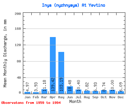
| Units: | m3/s |
| Statistic | Jan | Feb | Mar | Apr | May | Jun | Jul | Aug | Sep | Oct | Nov | Dec | Annual |
|---|---|---|---|---|---|---|---|---|---|---|---|---|---|
| Mean | 4.96 | 3.96 | 11.18 | 139.42 | 103.17 | 18.48 | 10.39 | 7.83 | 6.93 | 8.74 | 10.00 | 6.08 | 336.32 |
| Standard Deviation | 2.96 | 2.35 | 12.18 | 74.54 | 121.77 | 15.55 | 7.95 | 4.78 | 4.10 | 4.36 | 9.01 | 4.47 | 210.46 |
| Min | 1.39 | 0.93 | 1.20 | 33.85 | 9.98 | 2.48 | 1.33 | 1.11 | 1.18 | 2.48 | 1.35 | 1.11 | 87.25 |
| Max | 12.15 | 10.37 | 65.07 | 327.75 | 511.25 | 71.12 | 31.87 | 17.51 | 16.28 | 20.16 | 43.06 | 18.06 | 886.83 |
| Coefficient of Variation | 0.60 | 0.59 | 1.09 | 0.54 | 1.18 | 0.84 | 0.76 | 0.61 | 0.59 | 0.50 | 0.90 | 0.73 | 0.63 |
 Return to R-Arctic Net Home Page