|
|
|||||||||||||||||
| Point ID: 6896 | Downloads | Plots | Site Data | Code: 10552 |
|
|
|||||||||||||||||
| Download | |
|---|---|
| Site Descriptor Information | Site Time Series Data |
| Link to all available data | |
| View: | Time Series | All |
| Units: | mm |
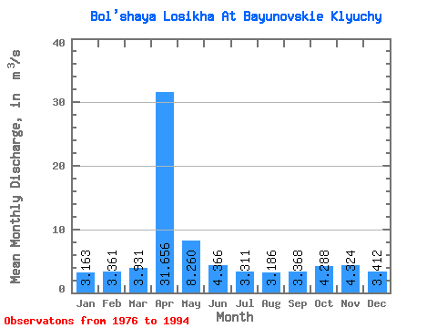
| Statistic | Jan | Feb | Mar | Apr | May | Jun | Jul | Aug | Sep | Oct | Nov | Dec | Annual |
|---|---|---|---|---|---|---|---|---|---|---|---|---|---|
| Mean | 3.16 | 3.36 | 3.93 | 31.66 | 8.26 | 4.37 | 3.31 | 3.19 | 3.37 | 4.29 | 4.32 | 3.41 | 6.40 |
| Standard Deviation | 0.67 | 0.83 | 1.23 | 10.36 | 3.52 | 0.90 | 0.35 | 0.42 | 0.42 | 0.45 | 0.68 | 0.79 | 0.91 |
| Min | 1.64 | 1.90 | 1.86 | 15.80 | 3.59 | 3.29 | 2.77 | 2.69 | 2.78 | 3.49 | 3.35 | 2.01 | 4.49 |
| Max | 4.40 | 5.14 | 6.56 | 46.60 | 19.50 | 6.06 | 4.02 | 4.02 | 4.25 | 5.05 | 5.96 | 4.84 | 8.15 |
| Coefficient of Variation | 0.21 | 0.25 | 0.31 | 0.33 | 0.43 | 0.21 | 0.11 | 0.13 | 0.12 | 0.10 | 0.16 | 0.23 | 0.14 |
 Return to R-Arctic Net Home Page