|
|
|||||||||||||||||
| Point ID: 6896 | Downloads | Plots | Site Data | Code: 10552 |
|
|
|||||||||||||||||
| Download | |
|---|---|
| Site Descriptor Information | Site Time Series Data |
| Link to all available data | |
| View: | Time Series | All |
| Units: | m3/s |
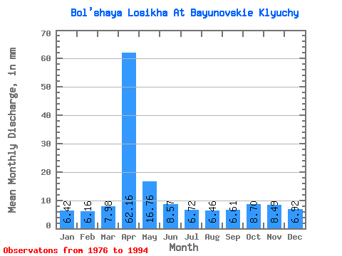
| Statistic | Jan | Feb | Mar | Apr | May | Jun | Jul | Aug | Sep | Oct | Nov | Dec | Annual |
|---|---|---|---|---|---|---|---|---|---|---|---|---|---|
| Mean | 6.42 | 6.21 | 7.97 | 62.16 | 16.76 | 8.57 | 6.72 | 6.46 | 6.61 | 8.70 | 8.49 | 6.92 | 152.96 |
| Standard Deviation | 1.35 | 1.53 | 2.50 | 20.35 | 7.14 | 1.77 | 0.72 | 0.86 | 0.82 | 0.91 | 1.33 | 1.60 | 21.69 |
| Min | 3.33 | 3.51 | 3.77 | 31.02 | 7.28 | 6.46 | 5.62 | 5.46 | 5.46 | 7.08 | 6.58 | 4.08 | 107.23 |
| Max | 8.93 | 9.50 | 13.31 | 91.50 | 39.56 | 11.90 | 8.16 | 8.16 | 8.35 | 10.24 | 11.70 | 9.82 | 194.82 |
| Coefficient of Variation | 0.21 | 0.25 | 0.31 | 0.33 | 0.43 | 0.21 | 0.11 | 0.13 | 0.12 | 0.10 | 0.16 | 0.23 | 0.14 |
 Return to R-Arctic Net Home Page