|
|
|||||||||||||||||
| Point ID: 6893 | Downloads | Plots | Site Data | Code: 10545 |
|
|
|||||||||||||||||
| Download | |
|---|---|
| Site Descriptor Information | Site Time Series Data |
| Link to all available data | |
| View: | Time Series | All |
| Units: | mm |
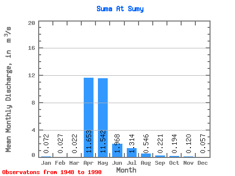
| Statistic | Jan | Feb | Mar | Apr | May | Jun | Jul | Aug | Sep | Oct | Nov | Dec | Annual |
|---|---|---|---|---|---|---|---|---|---|---|---|---|---|
| Mean | 0.07 | 0.03 | 0.02 | 11.65 | 11.54 | 1.97 | 1.31 | 0.55 | 0.22 | 0.19 | 0.12 | 0.06 | 6.53 |
| Standard Deviation | 0.22 | 0.05 | 0.03 | 10.73 | 19.18 | 4.03 | 4.04 | 1.26 | 0.59 | 0.50 | 0.28 | 0.16 | 5.00 |
| Min | 0.00 | 0.00 | 0.00 | 0.40 | 0.00 | 0.00 | 0.00 | 0.00 | 0.00 | 0.00 | 0.00 | 0.00 | 1.39 |
| Max | 0.79 | 0.17 | 0.10 | 41.50 | 94.20 | 20.30 | 20.10 | 6.07 | 2.75 | 2.01 | 1.10 | 0.66 | 14.28 |
| Coefficient of Variation | 3.02 | 1.99 | 1.42 | 0.92 | 1.66 | 2.05 | 3.07 | 2.32 | 2.66 | 2.57 | 2.36 | 2.82 | 0.77 |
 Return to R-Arctic Net Home Page