|
|
|||||||||||||||||
| Point ID: 6893 | Downloads | Plots | Site Data | Code: 10545 |
|
|
|||||||||||||||||
| Download | |
|---|---|
| Site Descriptor Information | Site Time Series Data |
| Link to all available data | |
| View: | Time Series | All |
| Units: | m3/s |
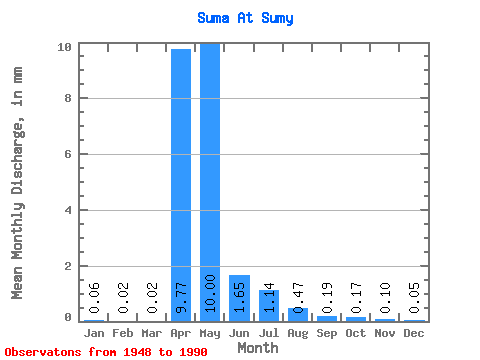
| Statistic | Jan | Feb | Mar | Apr | May | Jun | Jul | Aug | Sep | Oct | Nov | Dec | Annual |
|---|---|---|---|---|---|---|---|---|---|---|---|---|---|
| Mean | 0.06 | 0.02 | 0.02 | 9.78 | 10.00 | 1.65 | 1.14 | 0.47 | 0.19 | 0.17 | 0.10 | 0.05 | 66.66 |
| Standard Deviation | 0.19 | 0.04 | 0.03 | 9.00 | 16.62 | 3.38 | 3.50 | 1.09 | 0.49 | 0.43 | 0.24 | 0.14 | 51.12 |
| Min | 0.00 | 0.00 | 0.00 | 0.34 | 0.00 | 0.00 | 0.00 | 0.00 | 0.00 | 0.00 | 0.00 | 0.00 | 14.21 |
| Max | 0.69 | 0.13 | 0.09 | 34.81 | 81.64 | 17.03 | 17.42 | 5.26 | 2.31 | 1.74 | 0.92 | 0.57 | 145.85 |
| Coefficient of Variation | 3.02 | 1.99 | 1.42 | 0.92 | 1.66 | 2.05 | 3.07 | 2.32 | 2.66 | 2.57 | 2.36 | 2.82 | 0.77 |
 Return to R-Arctic Net Home Page