|
|
|||||||||||||||||
| Point ID: 6891 | Downloads | Plots | Site Data | Code: 10541 |
|
|
|||||||||||||||||
| Download | |
|---|---|
| Site Descriptor Information | Site Time Series Data |
| Link to all available data | |
| View: | Time Series | All |
| Units: | mm |
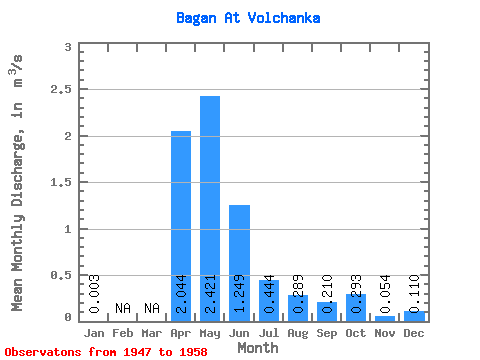
| Statistic | Jan | Feb | Mar | Apr | May | Jun | Jul | Aug | Sep | Oct | Nov | Dec | Annual |
|---|---|---|---|---|---|---|---|---|---|---|---|---|---|
| Mean | 0.00 | 2.04 | 2.42 | 1.25 | 0.44 | 0.29 | 0.21 | 0.29 | 0.05 | 0.11 | |||
| Standard Deviation | 2.16 | 2.93 | 1.76 | 0.87 | 0.49 | 0.43 | 0.46 | 0.09 | |||||
| Min | 0.00 | 0.11 | 0.01 | 0.00 | 0.00 | 0.00 | 0.00 | 0.00 | 0.00 | 0.11 | |||
| Max | 0.00 | 6.60 | 8.14 | 4.74 | 2.60 | 1.23 | 1.08 | 0.98 | 0.16 | 0.11 | |||
| Coefficient of Variation | 1.06 | 1.21 | 1.41 | 1.97 | 1.71 | 2.04 | 1.58 | 1.68 |
 Return to R-Arctic Net Home Page