|
|
|||||||||||||||||
| Point ID: 6891 | Downloads | Plots | Site Data | Code: 10541 |
|
|
|||||||||||||||||
| Download | |
|---|---|
| Site Descriptor Information | Site Time Series Data |
| Link to all available data | |
| View: | Time Series | All |
| Units: | m3/s |
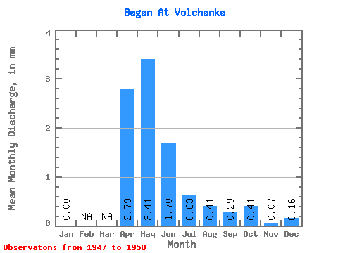
| Statistic | Jan | Feb | Mar | Apr | May | Jun | Jul | Aug | Sep | Oct | Nov | Dec | Annual |
|---|---|---|---|---|---|---|---|---|---|---|---|---|---|
| Mean | 0.00 | 2.79 | 3.41 | 1.70 | 0.63 | 0.41 | 0.29 | 0.41 | 0.07 | 0.15 | |||
| Standard Deviation | 2.95 | 4.12 | 2.41 | 1.23 | 0.70 | 0.58 | 0.65 | 0.12 | |||||
| Min | 0.00 | 0.15 | 0.01 | 0.00 | 0.00 | 0.00 | 0.00 | 0.00 | 0.00 | 0.15 | |||
| Max | 0.00 | 9.00 | 11.47 | 6.47 | 3.67 | 1.73 | 1.47 | 1.38 | 0.22 | 0.15 | |||
| Coefficient of Variation | 1.06 | 1.21 | 1.41 | 1.97 | 1.71 | 2.04 | 1.58 | 1.68 |
 Return to R-Arctic Net Home Page