|
|
|||||||||||||||||
| Point ID: 6888 | Downloads | Plots | Site Data | Code: 10538 |
|
|
|||||||||||||||||
| Download | |
|---|---|
| Site Descriptor Information | Site Time Series Data |
| Link to all available data | |
| View: | Time Series | All |
| Units: | mm |
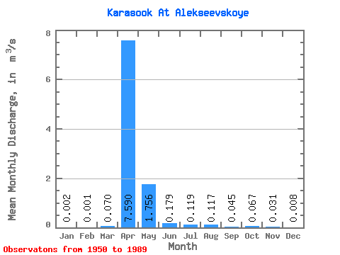
| Statistic | Jan | Feb | Mar | Apr | May | Jun | Jul | Aug | Sep | Oct | Nov | Dec | Annual |
|---|---|---|---|---|---|---|---|---|---|---|---|---|---|
| Mean | 0.00 | 0.00 | 0.07 | 7.59 | 1.76 | 0.18 | 0.12 | 0.12 | 0.04 | 0.07 | 0.03 | 0.01 | 0.90 |
| Standard Deviation | 0.00 | 0.00 | 0.10 | 5.09 | 2.23 | 0.39 | 0.28 | 0.39 | 0.07 | 0.07 | 0.04 | 0.01 | 0.64 |
| Min | 0.00 | 0.00 | 0.00 | 0.30 | 0.02 | 0.01 | 0.00 | 0.00 | 0.00 | 0.01 | 0.00 | 0.00 | 0.33 |
| Max | 0.00 | 0.00 | 0.26 | 22.40 | 7.96 | 1.69 | 1.49 | 2.23 | 0.37 | 0.30 | 0.21 | 0.02 | 1.58 |
| Coefficient of Variation | 1.08 | 2.00 | 1.37 | 0.67 | 1.27 | 2.17 | 2.33 | 3.29 | 1.57 | 1.03 | 1.40 | 0.81 | 0.71 |
 Return to R-Arctic Net Home Page