|
|
|||||||||||||||||
| Point ID: 6888 | Downloads | Plots | Site Data | Code: 10538 |
|
|
|||||||||||||||||
| Download | |
|---|---|
| Site Descriptor Information | Site Time Series Data |
| Link to all available data | |
| View: | Time Series | All |
| Units: | m3/s |
| Statistic | Jan | Feb | Mar | Apr | May | Jun | Jul | Aug | Sep | Oct | Nov | Dec | Annual |
|---|---|---|---|---|---|---|---|---|---|---|---|---|---|
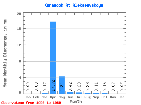
| Mean | 0.00 | 0.00 | 0.17 | 17.72 | 4.24 | 0.42 | 0.29 | 0.28 | 0.10 | 0.16 | 0.07 | 0.02 | 25.47 |
| Standard Deviation | 0.00 | 0.00 | 0.23 | 11.90 | 5.38 | 0.91 | 0.67 | 0.93 | 0.16 | 0.17 | 0.10 | 0.01 | 18.12 |
| Min | 0.00 | 0.00 | 0.00 | 0.70 | 0.05 | 0.01 | 0.00 | 0.00 | 0.00 | 0.01 | 0.00 | 0.00 | 9.27 |
| Max | 0.01 | 0.01 | 0.63 | 52.31 | 19.20 | 3.95 | 3.59 | 5.38 | 0.86 | 0.72 | 0.49 | 0.06 | 45.04 |
| Coefficient of Variation | 1.08 | 2.00 | 1.37 | 0.67 | 1.27 | 2.17 | 2.33 | 3.29 | 1.57 | 1.03 | 1.40 | 0.81 | 0.71 |
 Return to R-Arctic Net Home Page