|
|
|||||||||||||||||
| Point ID: 6886 | Downloads | Plots | Site Data | Code: 10524 |
|
|
|||||||||||||||||
| Download | |
|---|---|
| Site Descriptor Information | Site Time Series Data |
| Link to all available data | |
| View: | Time Series | All |
| Units: | mm |
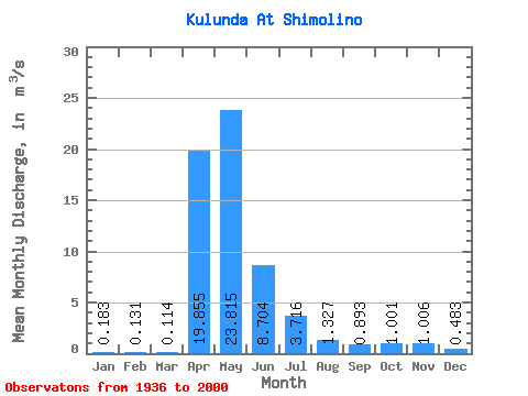
| Statistic | Jan | Feb | Mar | Apr | May | Jun | Jul | Aug | Sep | Oct | Nov | Dec | Annual |
|---|---|---|---|---|---|---|---|---|---|---|---|---|---|
| Mean | 0.18 | 0.13 | 0.11 | 19.86 | 23.82 | 8.70 | 3.72 | 1.33 | 0.89 | 1.00 | 1.01 | 0.48 | 5.27 |
| Standard Deviation | 0.22 | 0.17 | 0.15 | 18.82 | 18.16 | 6.29 | 3.61 | 1.57 | 0.98 | 1.07 | 1.14 | 0.54 | 3.35 |
| Min | 0.00 | 0.00 | 0.00 | 0.10 | 0.78 | 0.00 | 0.00 | 0.00 | 0.00 | 0.00 | 0.00 | 0.00 | 0.15 |
| Max | 0.91 | 0.68 | 0.64 | 74.30 | 92.50 | 26.00 | 13.20 | 6.51 | 3.74 | 4.84 | 4.96 | 2.07 | 12.19 |
| Coefficient of Variation | 1.20 | 1.27 | 1.30 | 0.95 | 0.76 | 0.72 | 0.97 | 1.19 | 1.10 | 1.07 | 1.13 | 1.12 | 0.64 |
 Return to R-Arctic Net Home Page