|
|
|||||||||||||||||
| Point ID: 6886 | Downloads | Plots | Site Data | Code: 10524 |
|
|
|||||||||||||||||
| Download | |
|---|---|
| Site Descriptor Information | Site Time Series Data |
| Link to all available data | |
| View: | Time Series | All |
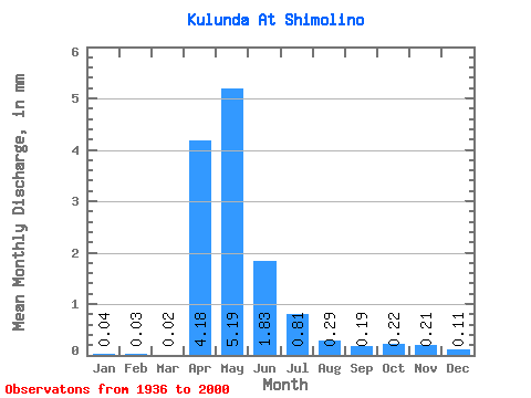
| Units: | m3/s |
| Statistic | Jan | Feb | Mar | Apr | May | Jun | Jul | Aug | Sep | Oct | Nov | Dec | Annual |
|---|---|---|---|---|---|---|---|---|---|---|---|---|---|
| Mean | 0.04 | 0.03 | 0.03 | 4.18 | 5.18 | 1.83 | 0.81 | 0.29 | 0.19 | 0.22 | 0.21 | 0.10 | 13.53 |
| Standard Deviation | 0.05 | 0.03 | 0.03 | 3.97 | 3.96 | 1.32 | 0.79 | 0.34 | 0.21 | 0.23 | 0.24 | 0.12 | 8.61 |
| Min | 0.00 | 0.00 | 0.00 | 0.02 | 0.17 | 0.00 | 0.00 | 0.00 | 0.00 | 0.00 | 0.00 | 0.00 | 0.39 |
| Max | 0.20 | 0.14 | 0.14 | 15.66 | 20.14 | 5.48 | 2.87 | 1.42 | 0.79 | 1.05 | 1.04 | 0.45 | 31.27 |
| Coefficient of Variation | 1.20 | 1.27 | 1.30 | 0.95 | 0.76 | 0.72 | 0.97 | 1.19 | 1.10 | 1.07 | 1.13 | 1.12 | 0.64 |
 Return to R-Arctic Net Home Page