|
|
|||||||||||||||||
| Point ID: 6885 | Downloads | Plots | Site Data | Code: 10522 |
|
|
|||||||||||||||||
| Download | |
|---|---|
| Site Descriptor Information | Site Time Series Data |
| Link to all available data | |
| View: | Time Series | All |
| Units: | mm |
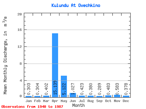
| Statistic | Jan | Feb | Mar | Apr | May | Jun | Jul | Aug | Sep | Oct | Nov | Dec | Annual |
|---|---|---|---|---|---|---|---|---|---|---|---|---|---|
| Mean | 0.30 | 0.30 | 0.40 | 15.14 | 5.12 | 1.03 | 0.42 | 0.38 | 0.29 | 0.48 | 0.58 | 0.38 | 2.06 |
| Standard Deviation | 0.19 | 0.19 | 0.30 | 9.11 | 3.98 | 0.78 | 0.32 | 0.39 | 0.21 | 0.36 | 0.45 | 0.29 | 0.98 |
| Min | 0.02 | 0.00 | 0.02 | 2.32 | 1.03 | 0.25 | 0.04 | 0.01 | 0.01 | 0.02 | 0.06 | 0.07 | 0.62 |
| Max | 0.82 | 0.86 | 1.72 | 41.00 | 18.80 | 4.93 | 1.86 | 2.42 | 0.85 | 1.78 | 2.23 | 1.34 | 4.34 |
| Coefficient of Variation | 0.64 | 0.61 | 0.74 | 0.60 | 0.78 | 0.76 | 0.76 | 1.03 | 0.71 | 0.74 | 0.77 | 0.76 | 0.48 |
 Return to R-Arctic Net Home Page