|
|
|||||||||||||||||
| Point ID: 6885 | Downloads | Plots | Site Data | Code: 10522 |
|
|
|||||||||||||||||
| Download | |
|---|---|
| Site Descriptor Information | Site Time Series Data |
| Link to all available data | |
| View: | Time Series | All |
| Units: | m3/s |
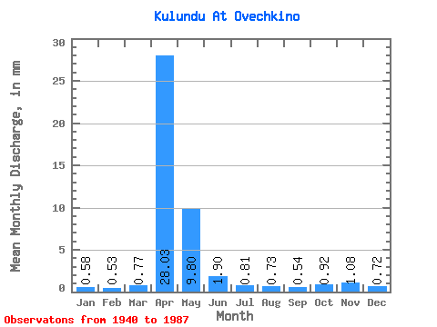
| Statistic | Jan | Feb | Mar | Apr | May | Jun | Jul | Aug | Sep | Oct | Nov | Dec | Annual |
|---|---|---|---|---|---|---|---|---|---|---|---|---|---|
| Mean | 0.58 | 0.53 | 0.77 | 28.03 | 9.80 | 1.90 | 0.81 | 0.73 | 0.54 | 0.92 | 1.08 | 0.72 | 46.38 |
| Standard Deviation | 0.37 | 0.32 | 0.57 | 16.86 | 7.61 | 1.44 | 0.62 | 0.75 | 0.38 | 0.69 | 0.83 | 0.55 | 22.10 |
| Min | 0.04 | 0.01 | 0.05 | 4.29 | 1.97 | 0.46 | 0.07 | 0.02 | 0.02 | 0.03 | 0.10 | 0.13 | 14.00 |
| Max | 1.57 | 1.50 | 3.29 | 75.91 | 35.96 | 9.13 | 3.56 | 4.63 | 1.57 | 3.41 | 4.13 | 2.56 | 97.80 |
| Coefficient of Variation | 0.64 | 0.61 | 0.74 | 0.60 | 0.78 | 0.76 | 0.76 | 1.03 | 0.71 | 0.74 | 0.77 | 0.76 | 0.48 |
 Return to R-Arctic Net Home Page