|
|
|||||||||||||||||
| Point ID: 6881 | Downloads | Plots | Site Data | Code: 10507 |
|
|
|||||||||||||||||
| Download | |
|---|---|
| Site Descriptor Information | Site Time Series Data |
| Link to all available data | |
| View: | Time Series | All |
| Units: | mm |
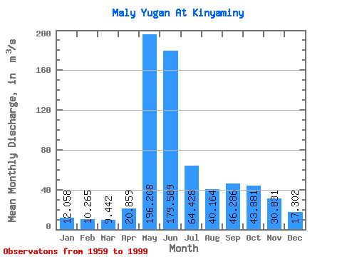
| Statistic | Jan | Feb | Mar | Apr | May | Jun | Jul | Aug | Sep | Oct | Nov | Dec | Annual |
|---|---|---|---|---|---|---|---|---|---|---|---|---|---|
| Mean | 12.06 | 10.27 | 9.44 | 20.86 | 196.21 | 179.59 | 64.43 | 40.16 | 46.29 | 43.88 | 30.83 | 17.30 | 55.42 |
| Standard Deviation | 2.98 | 1.95 | 1.39 | 20.89 | 47.69 | 84.29 | 45.04 | 28.54 | 39.38 | 30.67 | 16.97 | 7.19 | 16.30 |
| Min | 7.45 | 7.17 | 7.07 | 7.12 | 96.70 | 39.30 | 17.40 | 11.70 | 10.30 | 11.10 | 9.41 | 8.22 | 28.39 |
| Max | 17.60 | 14.60 | 12.30 | 121.00 | 275.00 | 344.00 | 192.00 | 124.00 | 152.00 | 124.00 | 61.60 | 35.80 | 99.48 |
| Coefficient of Variation | 0.25 | 0.19 | 0.15 | 1.00 | 0.24 | 0.47 | 0.70 | 0.71 | 0.85 | 0.70 | 0.55 | 0.41 | 0.29 |
 Return to R-Arctic Net Home Page