|
|
|||||||||||||||||
| Point ID: 6881 | Downloads | Plots | Site Data | Code: 10507 |
|
|
|||||||||||||||||
| Download | |
|---|---|
| Site Descriptor Information | Site Time Series Data |
| Link to all available data | |
| View: | Time Series | All |
| Units: | m3/s |
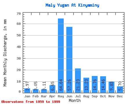
| Statistic | Jan | Feb | Mar | Apr | May | Jun | Jul | Aug | Sep | Oct | Nov | Dec | Annual |
|---|---|---|---|---|---|---|---|---|---|---|---|---|---|
| Mean | 3.97 | 3.08 | 3.11 | 6.65 | 64.63 | 57.26 | 21.22 | 13.23 | 14.76 | 14.45 | 9.83 | 5.70 | 215.15 |
| Standard Deviation | 0.98 | 0.59 | 0.46 | 6.66 | 15.71 | 26.87 | 14.84 | 9.40 | 12.56 | 10.10 | 5.41 | 2.37 | 63.29 |
| Min | 2.45 | 2.15 | 2.33 | 2.27 | 31.85 | 12.53 | 5.73 | 3.85 | 3.28 | 3.66 | 3.00 | 2.71 | 110.19 |
| Max | 5.80 | 4.38 | 4.05 | 38.58 | 90.58 | 109.67 | 63.24 | 40.84 | 48.46 | 40.84 | 19.64 | 11.79 | 386.19 |
| Coefficient of Variation | 0.25 | 0.19 | 0.15 | 1.00 | 0.24 | 0.47 | 0.70 | 0.71 | 0.85 | 0.70 | 0.55 | 0.41 | 0.29 |
 Return to R-Arctic Net Home Page