|
|
|||||||||||||||||
| Point ID: 6880 | Downloads | Plots | Site Data | Other Close Sites | Code: 10506 |
|
|
|||||||||||||||||
| Download | |
|---|---|
| Site Descriptor Information | Site Time Series Data |
| Link to all available data | |
| View: | Time Series | All |
| Units: | mm |
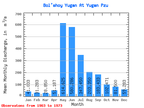
| Statistic | Jan | Feb | Mar | Apr | May | Jun | Jul | Aug | Sep | Oct | Nov | Dec | Annual |
|---|---|---|---|---|---|---|---|---|---|---|---|---|---|
| Mean | 41.03 | 31.28 | 28.85 | 51.19 | 614.62 | 580.29 | 347.45 | 203.35 | 183.43 | 102.47 | 81.50 | 59.28 | 177.67 |
| Standard Deviation | 12.87 | 6.72 | 3.64 | 38.26 | 179.74 | 230.18 | 219.22 | 106.42 | 186.48 | 35.80 | 37.24 | 24.26 | 64.25 |
| Min | 24.80 | 22.20 | 22.50 | 25.00 | 334.00 | 172.00 | 93.70 | 79.10 | 48.80 | 49.40 | 40.50 | 31.20 | 132.24 |
| Max | 62.40 | 40.60 | 32.30 | 141.00 | 863.00 | 906.00 | 622.00 | 336.00 | 553.00 | 144.00 | 122.00 | 88.70 | 223.10 |
| Coefficient of Variation | 0.31 | 0.21 | 0.13 | 0.75 | 0.29 | 0.40 | 0.63 | 0.52 | 1.02 | 0.35 | 0.46 | 0.41 | 0.36 |
| Other Close Sites | ||||||
|---|---|---|---|---|---|---|
| PointID | Latitude | Longitude | Drainage Area | Source | Name | |
| 6878 | "Bo'shoy Yugan At Ruskiny" | 60.27 | -910921 | SHI | 236.00 | |
| 6879 | "Bol'shoy Yugan At Ugut" | 60.50 | -893149 | SHI | 166.00 | |
 Return to R-Arctic Net Home Page