|
|
|||||||||||||||||
| Point ID: 6878 | Downloads | Plots | Site Data | Other Close Sites | Code: 10504 |
|
|
|||||||||||||||||
| Download | |
|---|---|
| Site Descriptor Information | Site Time Series Data |
| Link to all available data | |
| View: | Time Series | All |
| Units: | mm |
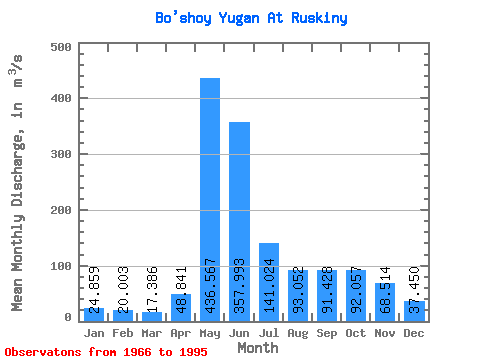
| Statistic | Jan | Feb | Mar | Apr | May | Jun | Jul | Aug | Sep | Oct | Nov | Dec | Annual |
|---|---|---|---|---|---|---|---|---|---|---|---|---|---|
| Mean | 24.86 | 20.00 | 17.39 | 48.84 | 436.57 | 357.99 | 141.02 | 93.05 | 91.43 | 92.06 | 68.51 | 37.45 | 119.97 |
| Standard Deviation | 7.66 | 4.82 | 2.35 | 54.39 | 109.80 | 154.83 | 96.62 | 70.38 | 64.90 | 59.29 | 40.66 | 16.45 | 31.71 |
| Min | 15.60 | 14.20 | 13.90 | 15.50 | 232.00 | 79.80 | 33.60 | 20.80 | 21.10 | 20.90 | 20.30 | 16.50 | 62.61 |
| Max | 45.40 | 33.80 | 24.10 | 268.00 | 603.00 | 691.00 | 425.00 | 293.00 | 232.00 | 243.00 | 179.00 | 73.20 | 191.67 |
| Coefficient of Variation | 0.31 | 0.24 | 0.14 | 1.11 | 0.25 | 0.43 | 0.69 | 0.76 | 0.71 | 0.64 | 0.59 | 0.44 | 0.26 |
| Other Close Sites | ||||||
|---|---|---|---|---|---|---|
| PointID | Latitude | Longitude | Drainage Area | Source | Name | |
| 6879 | "Bol'shoy Yugan At Ugut" | 60.50 | -893149 | SHI | 166.00 | |
| 6880 | "Bol'shoy Yugan At Yugan Pzu" | 60.67 | -898935 | SHI | 118.00 | |
 Return to R-Arctic Net Home Page