|
|
|||||||||||||||||
| Point ID: 688 | Downloads | Plots | Site Data | Code: 07CA010 |
|
|
|||||||||||||||||
| Download | |
|---|---|
| Site Descriptor Information | Site Time Series Data |
| Link to all available data | |
| View: | Time Series | All |
| Units: | mm |
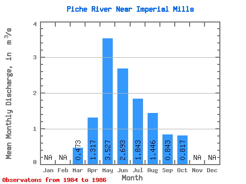
| Statistic | Jan | Feb | Mar | Apr | May | Jun | Jul | Aug | Sep | Oct | Nov | Dec | Annual |
|---|---|---|---|---|---|---|---|---|---|---|---|---|---|
| Mean | 0.47 | 1.32 | 3.53 | 2.69 | 1.84 | 1.45 | 0.84 | 0.82 | |||||
| Standard Deviation | 0.11 | 0.70 | 3.58 | 1.19 | 0.23 | 1.05 | 0.69 | 1.16 | |||||
| Min | 0.37 | 0.69 | 1.24 | 1.37 | 1.59 | 0.70 | 0.40 | 0.06 | |||||
| Max | 0.59 | 2.08 | 7.65 | 3.69 | 2.03 | 2.65 | 1.64 | 2.15 | |||||
| Coefficient of Variation | 0.24 | 0.54 | 1.01 | 0.44 | 0.12 | 0.73 | 0.82 | 1.42 |
 Return to R-Arctic Net Home Page