|
|
| Point ID: 688 | Downloads | Plots | Site Data | Code: 07CA010 |
|
| Download | |
|---|---|
| Site Descriptor Information | Site Time Series Data |
| Link to all available data | |
|
|
|
| View: | Statistics | All |
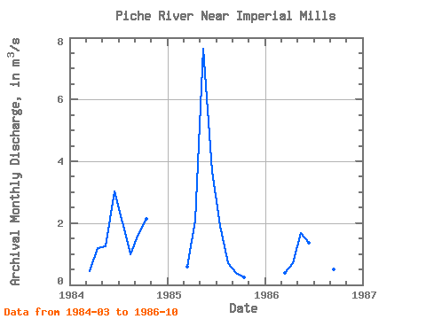
| Units: | mm |
| Year | Jan | Feb | Mar | Apr | May | Jun | Jul | Aug | Sep | Oct | Nov | Dec | Annual | 1984 | 0.45 | 1.18 | 1.24 | 3.02 | 2.03 | 0.99 | 1.64 | 2.15 | 1985 | 0.59 | 2.08 | 7.65 | 3.69 | 1.91 | 0.70 | 0.40 | 0.24 | 1986 | 0.37 | 0.69 | 1.69 | 1.37 | 1.59 | 2.65 | 0.49 | 0.06 |
|---|
 Return to R-Arctic Net Home Page