|
|
|||||||||||||||||
| Point ID: 6854 | Downloads | Plots | Site Data | Code: 10466 |
|
|
|||||||||||||||||
| Download | |
|---|---|
| Site Descriptor Information | Site Time Series Data |
| Link to all available data | |
| View: | Time Series | All |
| Units: | mm |
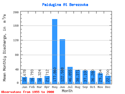
| Statistic | Jan | Feb | Mar | Apr | May | Jun | Jul | Aug | Sep | Oct | Nov | Dec | Annual |
|---|---|---|---|---|---|---|---|---|---|---|---|---|---|
| Mean | 18.68 | 16.79 | 16.32 | 21.71 | 177.86 | 122.59 | 46.85 | 38.37 | 37.10 | 36.28 | 29.15 | 22.70 | 49.09 |
| Standard Deviation | 4.03 | 2.88 | 2.33 | 7.41 | 64.72 | 57.34 | 18.17 | 14.50 | 13.86 | 12.06 | 9.18 | 6.44 | 10.79 |
| Min | 11.50 | 11.00 | 12.40 | 13.70 | 82.00 | 40.40 | 22.20 | 20.30 | 19.80 | 19.70 | 17.60 | 14.00 | 25.57 |
| Max | 28.50 | 21.60 | 23.10 | 42.00 | 361.00 | 298.00 | 124.00 | 94.20 | 79.30 | 72.10 | 66.50 | 44.60 | 71.69 |
| Coefficient of Variation | 0.22 | 0.17 | 0.14 | 0.34 | 0.36 | 0.47 | 0.39 | 0.38 | 0.37 | 0.33 | 0.32 | 0.28 | 0.22 |
 Return to R-Arctic Net Home Page