|
|
|||||||||||||||||
| Point ID: 6854 | Downloads | Plots | Site Data | Code: 10466 |
|
|
|||||||||||||||||
| Download | |
|---|---|
| Site Descriptor Information | Site Time Series Data |
| Link to all available data | |
| View: | Time Series | All |
| Units: | m3/s |
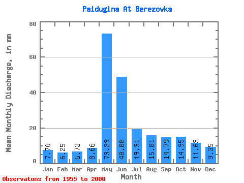
| Statistic | Jan | Feb | Mar | Apr | May | Jun | Jul | Aug | Sep | Oct | Nov | Dec | Annual |
|---|---|---|---|---|---|---|---|---|---|---|---|---|---|
| Mean | 7.70 | 6.30 | 6.72 | 8.66 | 73.28 | 48.88 | 19.30 | 15.81 | 14.79 | 14.95 | 11.63 | 9.35 | 238.36 |
| Standard Deviation | 1.66 | 1.08 | 0.96 | 2.96 | 26.67 | 22.87 | 7.49 | 5.97 | 5.53 | 4.97 | 3.66 | 2.65 | 52.40 |
| Min | 4.74 | 4.13 | 5.11 | 5.46 | 33.78 | 16.11 | 9.15 | 8.36 | 7.90 | 8.12 | 7.02 | 5.77 | 124.18 |
| Max | 11.74 | 8.11 | 9.52 | 16.75 | 148.73 | 118.83 | 51.09 | 38.81 | 31.62 | 29.70 | 26.52 | 18.38 | 348.09 |
| Coefficient of Variation | 0.22 | 0.17 | 0.14 | 0.34 | 0.36 | 0.47 | 0.39 | 0.38 | 0.37 | 0.33 | 0.32 | 0.28 | 0.22 |
 Return to R-Arctic Net Home Page