|
|
|||||||||||||||||
| Point ID: 6851 | Downloads | Plots | Site Data | Code: 10460 |
|
|
|||||||||||||||||
| Download | |
|---|---|
| Site Descriptor Information | Site Time Series Data |
| Link to all available data | |
| View: | Time Series | All |
| Units: | mm |
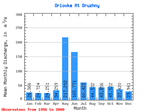
| Statistic | Jan | Feb | Mar | Apr | May | Jun | Jul | Aug | Sep | Oct | Nov | Dec | Annual |
|---|---|---|---|---|---|---|---|---|---|---|---|---|---|
| Mean | 26.37 | 24.72 | 24.25 | 34.26 | 217.20 | 165.77 | 60.42 | 44.53 | 43.86 | 45.52 | 37.42 | 29.94 | 62.85 |
| Standard Deviation | 4.54 | 3.97 | 3.64 | 12.62 | 84.53 | 70.02 | 19.41 | 11.35 | 12.37 | 16.20 | 10.58 | 6.43 | 13.71 |
| Min | 18.60 | 17.60 | 18.00 | 18.10 | 92.30 | 58.80 | 33.90 | 26.50 | 29.60 | 24.50 | 24.30 | 17.40 | 37.34 |
| Max | 41.10 | 36.90 | 33.10 | 73.80 | 493.00 | 312.00 | 138.00 | 72.40 | 80.00 | 92.30 | 80.80 | 48.50 | 102.72 |
| Coefficient of Variation | 0.17 | 0.16 | 0.15 | 0.37 | 0.39 | 0.42 | 0.32 | 0.26 | 0.28 | 0.36 | 0.28 | 0.21 | 0.22 |
 Return to R-Arctic Net Home Page