|
|
|||||||||||||||||
| Point ID: 6851 | Downloads | Plots | Site Data | Code: 10460 |
|
|
|||||||||||||||||
| Download | |
|---|---|
| Site Descriptor Information | Site Time Series Data |
| Link to all available data | |
| View: | Time Series | All |
| Units: | m3/s |
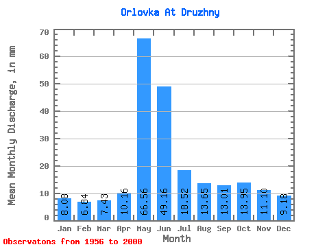
| Statistic | Jan | Feb | Mar | Apr | May | Jun | Jul | Aug | Sep | Oct | Nov | Dec | Annual |
|---|---|---|---|---|---|---|---|---|---|---|---|---|---|
| Mean | 8.08 | 6.90 | 7.43 | 10.16 | 66.55 | 49.16 | 18.51 | 13.64 | 13.01 | 13.95 | 11.10 | 9.17 | 226.97 |
| Standard Deviation | 1.39 | 1.11 | 1.11 | 3.74 | 25.90 | 20.77 | 5.95 | 3.48 | 3.67 | 4.96 | 3.14 | 1.97 | 49.51 |
| Min | 5.70 | 4.91 | 5.51 | 5.37 | 28.28 | 17.44 | 10.39 | 8.12 | 8.78 | 7.51 | 7.21 | 5.33 | 134.84 |
| Max | 12.59 | 10.30 | 10.14 | 21.89 | 151.06 | 92.53 | 42.28 | 22.18 | 23.73 | 28.28 | 23.96 | 14.86 | 370.91 |
| Coefficient of Variation | 0.17 | 0.16 | 0.15 | 0.37 | 0.39 | 0.42 | 0.32 | 0.26 | 0.28 | 0.36 | 0.28 | 0.21 | 0.22 |
 Return to R-Arctic Net Home Page