|
|
|||||||||||||||||
| Point ID: 6840 | Downloads | Plots | Site Data | Code: 10432 |
|
|
|||||||||||||||||
| Download | |
|---|---|
| Site Descriptor Information | Site Time Series Data |
| Link to all available data | |
| View: | Time Series | All |
| Units: | mm |
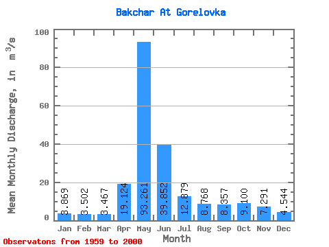
| Statistic | Jan | Feb | Mar | Apr | May | Jun | Jul | Aug | Sep | Oct | Nov | Dec | Annual |
|---|---|---|---|---|---|---|---|---|---|---|---|---|---|
| Mean | 3.87 | 3.50 | 3.47 | 19.12 | 93.26 | 39.85 | 12.88 | 8.77 | 8.36 | 9.10 | 7.29 | 4.54 | 17.74 |
| Standard Deviation | 0.95 | 0.78 | 0.73 | 16.51 | 61.56 | 31.99 | 14.58 | 7.89 | 5.83 | 6.36 | 4.53 | 1.85 | 9.62 |
| Min | 2.60 | 2.06 | 2.40 | 3.95 | 7.94 | 5.73 | 3.54 | 2.95 | 3.13 | 2.92 | 2.46 | 0.50 | 5.07 |
| Max | 7.13 | 6.10 | 5.75 | 73.60 | 229.00 | 142.00 | 71.30 | 29.10 | 25.50 | 27.20 | 17.80 | 10.60 | 47.96 |
| Coefficient of Variation | 0.24 | 0.22 | 0.21 | 0.86 | 0.66 | 0.80 | 1.13 | 0.90 | 0.70 | 0.70 | 0.62 | 0.41 | 0.54 |
 Return to R-Arctic Net Home Page