|
|
|||||||||||||||||
| Point ID: 6840 | Downloads | Plots | Site Data | Code: 10432 |
|
|
|||||||||||||||||
| Download | |
|---|---|
| Site Descriptor Information | Site Time Series Data |
| Link to all available data | |
| View: | Time Series | All |
| Units: | m3/s |
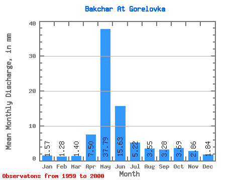
| Statistic | Jan | Feb | Mar | Apr | May | Jun | Jul | Aug | Sep | Oct | Nov | Dec | Annual |
|---|---|---|---|---|---|---|---|---|---|---|---|---|---|
| Mean | 1.57 | 1.29 | 1.41 | 7.50 | 37.78 | 15.63 | 5.22 | 3.55 | 3.28 | 3.69 | 2.86 | 1.84 | 84.71 |
| Standard Deviation | 0.38 | 0.29 | 0.29 | 6.47 | 24.94 | 12.54 | 5.91 | 3.20 | 2.29 | 2.58 | 1.78 | 0.75 | 45.95 |
| Min | 1.05 | 0.76 | 0.97 | 1.55 | 3.22 | 2.25 | 1.43 | 1.20 | 1.23 | 1.18 | 0.96 | 0.20 | 24.20 |
| Max | 2.89 | 2.25 | 2.33 | 28.86 | 92.78 | 55.68 | 28.89 | 11.79 | 10.00 | 11.02 | 6.98 | 4.29 | 228.98 |
| Coefficient of Variation | 0.24 | 0.22 | 0.21 | 0.86 | 0.66 | 0.80 | 1.13 | 0.90 | 0.70 | 0.70 | 0.62 | 0.41 | 0.54 |
 Return to R-Arctic Net Home Page