|
|
|||||||||||||||||
| Point ID: 6833 | Downloads | Plots | Site Data | Code: 10421 |
|
|
|||||||||||||||||
| Download | |
|---|---|
| Site Descriptor Information | Site Time Series Data |
| Link to all available data | |
| View: | Time Series | All |
| Units: | mm |
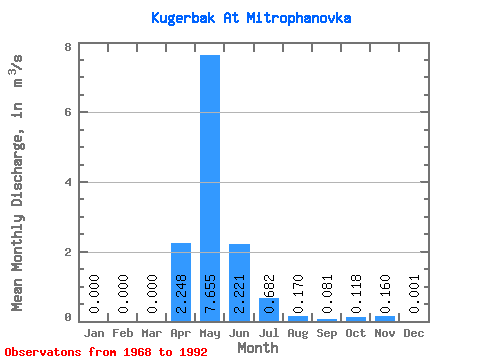
| Statistic | Jan | Feb | Mar | Apr | May | Jun | Jul | Aug | Sep | Oct | Nov | Dec | Annual |
|---|---|---|---|---|---|---|---|---|---|---|---|---|---|
| Mean | 0.00 | 0.00 | 0.00 | 2.25 | 7.66 | 2.22 | 0.68 | 0.17 | 0.08 | 0.12 | 0.16 | 0.00 | 0.28 |
| Standard Deviation | 0.00 | 0.00 | 0.00 | 2.97 | 6.92 | 1.94 | 1.49 | 0.39 | 0.18 | 0.19 | 0.29 | 0.00 | 0.07 |
| Min | 0.00 | 0.00 | 0.00 | 0.00 | 1.08 | 0.03 | 0.00 | 0.00 | 0.00 | 0.00 | 0.00 | 0.00 | 0.22 |
| Max | 0.00 | 0.00 | 0.00 | 9.37 | 23.80 | 6.73 | 6.53 | 1.36 | 0.50 | 0.57 | 0.84 | 0.01 | 0.37 |
| Coefficient of Variation | 1.32 | 0.90 | 0.87 | 2.19 | 2.28 | 2.19 | 1.61 | 1.80 | 2.65 | 0.25 |
 Return to R-Arctic Net Home Page