|
|
|||||||||||||||||
| Point ID: 6833 | Downloads | Plots | Site Data | Code: 10421 |
|
|
|||||||||||||||||
| Download | |
|---|---|
| Site Descriptor Information | Site Time Series Data |
| Link to all available data | |
| View: | Time Series | All |
| Units: | m3/s |
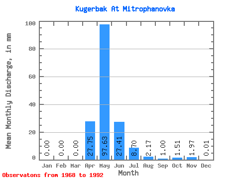
| Statistic | Jan | Feb | Mar | Apr | May | Jun | Jul | Aug | Sep | Oct | Nov | Dec | Annual |
|---|---|---|---|---|---|---|---|---|---|---|---|---|---|
| Mean | 0.00 | 0.00 | 0.00 | 27.75 | 97.62 | 27.42 | 8.70 | 2.16 | 0.99 | 1.50 | 1.98 | 0.02 | 42.06 |
| Standard Deviation | 0.00 | 0.00 | 0.00 | 36.69 | 88.21 | 23.96 | 19.06 | 4.92 | 2.18 | 2.42 | 3.56 | 0.05 | 10.36 |
| Min | 0.00 | 0.00 | 0.00 | 0.00 | 13.77 | 0.37 | 0.00 | 0.00 | 0.00 | 0.00 | 0.00 | 0.00 | 33.21 |
| Max | 0.00 | 0.00 | 0.00 | 115.65 | 303.51 | 83.07 | 83.27 | 17.34 | 6.17 | 7.27 | 10.37 | 0.13 | 56.26 |
| Coefficient of Variation | 1.32 | 0.90 | 0.87 | 2.19 | 2.28 | 2.19 | 1.61 | 1.80 | 2.65 | 0.25 |
 Return to R-Arctic Net Home Page