|
|
|||||||||||||||||
| Point ID: 681 | Downloads | Plots | Site Data | Code: 07BK007 |
|
|
|||||||||||||||||
| Download | |
|---|---|
| Site Descriptor Information | Site Time Series Data |
| Link to all available data | |
| View: | Time Series | All |
| Units: | mm |
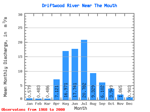
| Statistic | Jan | Feb | Mar | Apr | May | Jun | Jul | Aug | Sep | Oct | Nov | Dec | Annual |
|---|---|---|---|---|---|---|---|---|---|---|---|---|---|
| Mean | 0.58 | 0.48 | 0.49 | 7.12 | 16.97 | 17.74 | 20.78 | 9.33 | 6.10 | 3.95 | 1.86 | 0.90 | 7.23 |
| Standard Deviation | 0.51 | 0.43 | 0.34 | 6.65 | 13.20 | 12.42 | 19.04 | 10.55 | 6.62 | 4.28 | 1.87 | 0.90 | 4.35 |
| Min | 0.00 | 0.00 | 0.02 | 0.42 | 2.68 | 1.14 | 0.32 | 0.21 | 0.08 | 0.13 | 0.09 | 0.03 | 0.71 |
| Max | 1.88 | 1.82 | 1.44 | 30.30 | 57.20 | 53.40 | 76.20 | 53.20 | 25.60 | 16.10 | 7.06 | 3.59 | 18.63 |
| Coefficient of Variation | 0.89 | 0.89 | 0.70 | 0.93 | 0.78 | 0.70 | 0.92 | 1.13 | 1.08 | 1.08 | 1.00 | 1.00 | 0.60 |
 Return to R-Arctic Net Home Page