|
|
|||||||||||||||||
| Point ID: 681 | Downloads | Plots | Site Data | Code: 07BK007 |
|
|
|||||||||||||||||
| Download | |
|---|---|
| Site Descriptor Information | Site Time Series Data |
| Link to all available data | |
| View: | Time Series | All |
| Units: | m3/s |
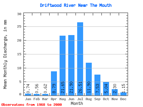
| Statistic | Jan | Feb | Mar | Apr | May | Jun | Jul | Aug | Sep | Oct | Nov | Dec | Annual |
|---|---|---|---|---|---|---|---|---|---|---|---|---|---|
| Mean | 0.74 | 0.56 | 0.62 | 8.79 | 21.64 | 21.90 | 26.50 | 11.90 | 7.53 | 5.04 | 2.30 | 1.15 | 108.60 |
| Standard Deviation | 0.66 | 0.50 | 0.43 | 8.21 | 16.83 | 15.33 | 24.28 | 13.46 | 8.17 | 5.46 | 2.31 | 1.15 | 65.36 |
| Min | 0.00 | 0.00 | 0.02 | 0.53 | 3.42 | 1.41 | 0.40 | 0.27 | 0.10 | 0.16 | 0.11 | 0.03 | 10.62 |
| Max | 2.40 | 2.12 | 1.84 | 37.40 | 72.94 | 65.91 | 97.17 | 67.84 | 31.60 | 20.53 | 8.71 | 4.58 | 280.03 |
| Coefficient of Variation | 0.89 | 0.89 | 0.70 | 0.93 | 0.78 | 0.70 | 0.92 | 1.13 | 1.08 | 1.08 | 1.00 | 1.00 | 0.60 |
 Return to R-Arctic Net Home Page