|
|
|||||||||||||||||
| Point ID: 6808 | Downloads | Plots | Site Data | Code: 10378 |
|
|
|||||||||||||||||
| Download | |
|---|---|
| Site Descriptor Information | Site Time Series Data |
| Link to all available data | |
| View: | Time Series | All |
| Units: | mm |
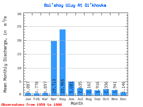
| Statistic | Jan | Feb | Mar | Apr | May | Jun | Jul | Aug | Sep | Oct | Nov | Dec | Annual |
|---|---|---|---|---|---|---|---|---|---|---|---|---|---|
| Mean | 0.89 | 0.78 | 0.90 | 19.71 | 23.95 | 5.08 | 2.63 | 2.16 | 1.92 | 2.34 | 1.94 | 1.15 | 5.29 |
| Standard Deviation | 0.34 | 0.31 | 0.56 | 10.39 | 12.51 | 2.65 | 2.24 | 1.60 | 1.01 | 1.04 | 1.43 | 0.40 | 1.25 |
| Min | 0.11 | 0.26 | 0.29 | 3.28 | 5.49 | 1.25 | 1.02 | 0.62 | 0.80 | 1.10 | 0.68 | 0.46 | 2.54 |
| Max | 1.50 | 1.55 | 3.62 | 45.60 | 62.00 | 13.80 | 11.90 | 6.86 | 5.26 | 5.20 | 8.90 | 1.90 | 7.45 |
| Coefficient of Variation | 0.38 | 0.40 | 0.63 | 0.53 | 0.52 | 0.52 | 0.85 | 0.74 | 0.53 | 0.45 | 0.74 | 0.35 | 0.24 |
 Return to R-Arctic Net Home Page