|
|
|||||||||||||||||
| Point ID: 6808 | Downloads | Plots | Site Data | Code: 10378 |
|
|
|||||||||||||||||
| Download | |
|---|---|
| Site Descriptor Information | Site Time Series Data |
| Link to all available data | |
| View: | Time Series | All |
| Units: | m3/s |
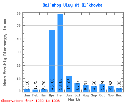
| Statistic | Jan | Feb | Mar | Apr | May | Jun | Jul | Aug | Sep | Oct | Nov | Dec | Annual |
|---|---|---|---|---|---|---|---|---|---|---|---|---|---|
| Mean | 2.18 | 1.74 | 2.20 | 46.88 | 58.85 | 12.08 | 6.47 | 5.31 | 4.56 | 5.74 | 4.62 | 2.82 | 153.09 |
| Standard Deviation | 0.83 | 0.69 | 1.39 | 24.71 | 30.73 | 6.29 | 5.51 | 3.94 | 2.40 | 2.56 | 3.40 | 0.98 | 36.16 |
| Min | 0.27 | 0.58 | 0.71 | 7.80 | 13.49 | 2.97 | 2.51 | 1.52 | 1.90 | 2.70 | 1.62 | 1.13 | 73.52 |
| Max | 3.69 | 3.47 | 8.89 | 108.44 | 152.33 | 32.82 | 29.24 | 16.85 | 12.51 | 12.78 | 21.16 | 4.67 | 215.61 |
| Coefficient of Variation | 0.38 | 0.40 | 0.63 | 0.53 | 0.52 | 0.52 | 0.85 | 0.74 | 0.53 | 0.45 | 0.74 | 0.35 | 0.24 |
 Return to R-Arctic Net Home Page