|
|
|||||||||||||||||
| Point ID: 6807 | Downloads | Plots | Site Data | Code: 10377 |
|
|
|||||||||||||||||
| Download | |
|---|---|
| Site Descriptor Information | Site Time Series Data |
| Link to all available data | |
| View: | Time Series | All |
| Units: | mm |
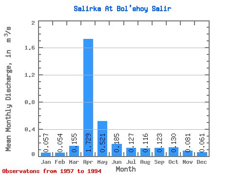
| Statistic | Jan | Feb | Mar | Apr | May | Jun | Jul | Aug | Sep | Oct | Nov | Dec | Annual |
|---|---|---|---|---|---|---|---|---|---|---|---|---|---|
| Mean | 0.06 | 0.05 | 0.15 | 1.73 | 0.52 | 0.18 | 0.13 | 0.12 | 0.12 | 0.13 | 0.08 | 0.06 | 0.28 |
| Standard Deviation | 0.03 | 0.03 | 0.18 | 0.96 | 0.43 | 0.07 | 0.06 | 0.05 | 0.04 | 0.05 | 0.03 | 0.03 | 0.10 |
| Min | 0.02 | 0.01 | 0.03 | 0.23 | 0.14 | 0.07 | 0.05 | 0.04 | 0.05 | 0.01 | 0.03 | 0.01 | 0.14 |
| Max | 0.13 | 0.11 | 0.84 | 3.89 | 2.24 | 0.34 | 0.30 | 0.23 | 0.26 | 0.27 | 0.16 | 0.16 | 0.51 |
| Coefficient of Variation | 0.52 | 0.51 | 1.18 | 0.55 | 0.83 | 0.38 | 0.46 | 0.43 | 0.37 | 0.39 | 0.37 | 0.50 | 0.34 |
 Return to R-Arctic Net Home Page