|
|
|||||||||||||||||
| Point ID: 6807 | Downloads | Plots | Site Data | Code: 10377 |
|
|
|||||||||||||||||
| Download | |
|---|---|
| Site Descriptor Information | Site Time Series Data |
| Link to all available data | |
| View: | Time Series | All |
| Units: | m3/s |
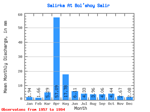
| Statistic | Jan | Feb | Mar | Apr | May | Jun | Jul | Aug | Sep | Oct | Nov | Dec | Annual |
|---|---|---|---|---|---|---|---|---|---|---|---|---|---|
| Mean | 1.96 | 1.67 | 5.29 | 57.10 | 17.78 | 6.10 | 4.33 | 3.96 | 4.06 | 4.42 | 2.68 | 2.09 | 113.47 |
| Standard Deviation | 1.02 | 0.84 | 6.22 | 31.63 | 14.78 | 2.32 | 2.01 | 1.72 | 1.48 | 1.73 | 1.00 | 1.05 | 38.43 |
| Min | 0.58 | 0.19 | 0.89 | 7.59 | 4.78 | 2.15 | 1.71 | 1.54 | 1.78 | 0.44 | 0.96 | 0.38 | 58.06 |
| Max | 4.43 | 3.42 | 28.66 | 128.44 | 76.42 | 11.23 | 10.23 | 7.85 | 8.59 | 9.21 | 5.28 | 5.46 | 202.93 |
| Coefficient of Variation | 0.52 | 0.51 | 1.18 | 0.55 | 0.83 | 0.38 | 0.46 | 0.43 | 0.37 | 0.39 | 0.37 | 0.50 | 0.34 |
 Return to R-Arctic Net Home Page