|
|
|||||||||||||||||
| Point ID: 6800 | Downloads | Plots | Site Data | Code: 10344 |
|
|
|||||||||||||||||
| Download | |
|---|---|
| Site Descriptor Information | Site Time Series Data |
| Link to all available data | |
| View: | Time Series | All |
| Units: | mm |
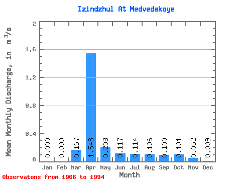
| Statistic | Jan | Feb | Mar | Apr | May | Jun | Jul | Aug | Sep | Oct | Nov | Dec | Annual |
|---|---|---|---|---|---|---|---|---|---|---|---|---|---|
| Mean | 0.00 | 0.00 | 0.17 | 1.55 | 0.21 | 0.12 | 0.11 | 0.11 | 0.10 | 0.10 | 0.05 | 0.01 | 0.21 |
| Standard Deviation | 0.00 | 0.00 | 0.49 | 1.09 | 0.12 | 0.06 | 0.07 | 0.04 | 0.04 | 0.04 | 0.04 | 0.01 | 0.11 |
| Min | 0.00 | 0.00 | 0.00 | 0.26 | 0.02 | 0.04 | 0.04 | 0.06 | 0.04 | 0.02 | 0.00 | 0.00 | 0.09 |
| Max | 0.01 | 0.00 | 2.42 | 4.10 | 0.54 | 0.27 | 0.40 | 0.21 | 0.18 | 0.20 | 0.15 | 0.05 | 0.41 |
| Coefficient of Variation | 3.65 | 2.95 | 0.70 | 0.58 | 0.51 | 0.60 | 0.37 | 0.37 | 0.42 | 0.69 | 1.68 | 0.51 |
 Return to R-Arctic Net Home Page