|
|
|||||||||||||||||
| Point ID: 6800 | Downloads | Plots | Site Data | Code: 10344 |
|
|
|||||||||||||||||
| Download | |
|---|---|
| Site Descriptor Information | Site Time Series Data |
| Link to all available data | |
| View: | Time Series | All |
| Units: | m3/s |
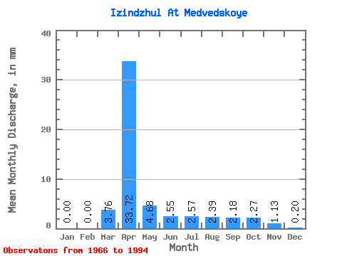
| Statistic | Jan | Feb | Mar | Apr | May | Jun | Jul | Aug | Sep | Oct | Nov | Dec | Annual |
|---|---|---|---|---|---|---|---|---|---|---|---|---|---|
| Mean | 0.01 | 0.00 | 3.76 | 33.72 | 4.67 | 2.56 | 2.56 | 2.39 | 2.17 | 2.28 | 1.14 | 0.20 | 55.47 |
| Standard Deviation | 0.03 | 0.00 | 11.07 | 23.73 | 2.70 | 1.30 | 1.55 | 0.88 | 0.81 | 0.96 | 0.78 | 0.34 | 28.04 |
| Min | 0.00 | 0.00 | 0.00 | 5.66 | 0.41 | 0.76 | 1.01 | 1.24 | 0.89 | 0.49 | 0.07 | 0.00 | 24.27 |
| Max | 0.11 | 0.00 | 54.46 | 89.30 | 12.15 | 5.88 | 9.00 | 4.73 | 3.92 | 4.50 | 3.27 | 1.12 | 109.05 |
| Coefficient of Variation | 3.65 | 2.95 | 0.70 | 0.58 | 0.51 | 0.60 | 0.37 | 0.37 | 0.42 | 0.69 | 1.68 | 0.51 |
 Return to R-Arctic Net Home Page