|
|
|||||||||||||||||
| Point ID: 680 | Downloads | Plots | Site Data | Other Close Sites | Code: 07BK006 |
|
|
|||||||||||||||||
| Download | |
|---|---|
| Site Descriptor Information | Site Time Series Data |
| Link to all available data | |
| View: | Time Series | All |
| Units: | mm |
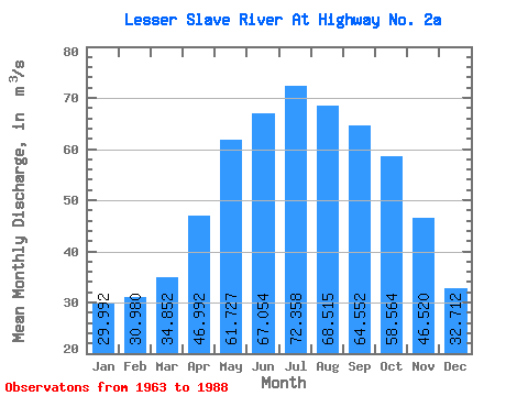
| Statistic | Jan | Feb | Mar | Apr | May | Jun | Jul | Aug | Sep | Oct | Nov | Dec | Annual |
|---|---|---|---|---|---|---|---|---|---|---|---|---|---|
| Mean | 29.99 | 30.98 | 34.85 | 46.99 | 61.73 | 67.05 | 72.36 | 68.52 | 64.55 | 58.56 | 46.52 | 32.71 | 50.91 |
| Standard Deviation | 11.02 | 12.20 | 14.38 | 16.89 | 22.59 | 22.38 | 25.38 | 23.82 | 24.70 | 23.07 | 21.09 | 12.64 | 17.25 |
| Min | 13.40 | 13.00 | 14.60 | 20.20 | 27.50 | 29.10 | 26.40 | 23.50 | 25.50 | 25.10 | 17.30 | 13.50 | 22.33 |
| Max | 46.80 | 51.20 | 59.60 | 82.10 | 105.00 | 117.00 | 132.00 | 119.00 | 108.00 | 97.60 | 87.10 | 57.10 | 84.50 |
| Coefficient of Variation | 0.37 | 0.39 | 0.41 | 0.36 | 0.37 | 0.33 | 0.35 | 0.35 | 0.38 | 0.39 | 0.45 | 0.39 | 0.34 |
| Other Close Sites | ||||||
|---|---|---|---|---|---|---|
| PointID | Latitude | Longitude | Drainage Area | Source | Name | |
| 675 | "LESSER SLAVE RIVER AT SLAVE LAKE" | 55.30 | 1590866 | Hydat | ||
 Return to R-Arctic Net Home Page