|
|
|||||||||||||||||
| Point ID: 680 | Downloads | Plots | Site Data | Other Close Sites | Code: 07BK006 |
|
|
|||||||||||||||||
| Download | |
|---|---|
| Site Descriptor Information | Site Time Series Data |
| Link to all available data | |
| View: | Time Series | All |
| Units: | m3/s |
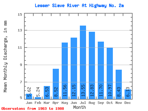
| Statistic | Jan | Feb | Mar | Apr | May | Jun | Jul | Aug | Sep | Oct | Nov | Dec | Annual |
|---|---|---|---|---|---|---|---|---|---|---|---|---|---|
| Mean | 5.58 | 5.25 | 6.48 | 8.46 | 11.48 | 12.07 | 13.46 | 12.74 | 11.62 | 10.89 | 8.37 | 6.08 | 111.58 |
| Standard Deviation | 2.05 | 2.07 | 2.67 | 3.04 | 4.20 | 4.03 | 4.72 | 4.43 | 4.45 | 4.29 | 3.80 | 2.35 | 37.81 |
| Min | 2.49 | 2.20 | 2.71 | 3.64 | 5.11 | 5.24 | 4.91 | 4.37 | 4.59 | 4.67 | 3.11 | 2.51 | 48.95 |
| Max | 8.70 | 8.68 | 11.08 | 14.78 | 19.53 | 21.06 | 24.55 | 22.13 | 19.44 | 18.15 | 15.68 | 10.62 | 185.20 |
| Coefficient of Variation | 0.37 | 0.39 | 0.41 | 0.36 | 0.37 | 0.33 | 0.35 | 0.35 | 0.38 | 0.39 | 0.45 | 0.39 | 0.34 |
| Other Close Sites | ||||||
|---|---|---|---|---|---|---|
| PointID | Latitude | Longitude | Drainage Area | Source | Name | |
| 675 | "LESSER SLAVE RIVER AT SLAVE LAKE" | 55.30 | 1590866 | Hydat | ||
 Return to R-Arctic Net Home Page