|
|
|||||||||||||||||
| Point ID: 68 | Downloads | Plots | Site Data | Code: 05AC023 |
|
|
|||||||||||||||||
| Download | |
|---|---|
| Site Descriptor Information | Site Time Series Data |
| Link to all available data | |
| View: | Time Series | All |
| Units: | mm |
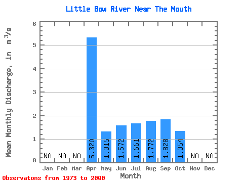
| Statistic | Jan | Feb | Mar | Apr | May | Jun | Jul | Aug | Sep | Oct | Nov | Dec | Annual |
|---|---|---|---|---|---|---|---|---|---|---|---|---|---|
| Mean | 5.32 | 1.31 | 1.57 | 1.66 | 1.77 | 1.83 | 1.35 | ||||||
| Standard Deviation | 0.69 | 0.68 | 0.93 | 0.72 | 0.68 | 0.41 | |||||||
| Min | 5.32 | 0.62 | 0.55 | 0.51 | 0.74 | 0.91 | 0.71 | ||||||
| Max | 5.32 | 3.64 | 4.19 | 4.89 | 4.31 | 3.40 | 2.64 | ||||||
| Coefficient of Variation | 0.53 | 0.43 | 0.56 | 0.40 | 0.37 | 0.30 |
 Return to R-Arctic Net Home Page