|
|
|||||||||||||||||
| Point ID: 68 | Downloads | Plots | Site Data | Code: 05AC023 |
|
|
|||||||||||||||||
| Download | |
|---|---|
| Site Descriptor Information | Site Time Series Data |
| Link to all available data | |
| View: | Time Series | All |
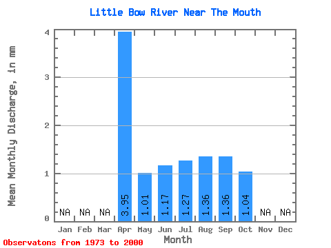
| Units: | m3/s |
| Statistic | Jan | Feb | Mar | Apr | May | Jun | Jul | Aug | Sep | Oct | Nov | Dec | Annual |
|---|---|---|---|---|---|---|---|---|---|---|---|---|---|
| Mean | 2.33 | 0.59 | 0.69 | 0.75 | 0.80 | 0.80 | 0.61 | ||||||
| Standard Deviation | 0.31 | 0.30 | 0.42 | 0.32 | 0.30 | 0.19 | |||||||
| Min | 2.33 | 0.28 | 0.24 | 0.23 | 0.34 | 0.40 | 0.32 | ||||||
| Max | 2.33 | 1.65 | 1.83 | 2.21 | 1.95 | 1.49 | 1.19 | ||||||
| Coefficient of Variation | 0.53 | 0.43 | 0.56 | 0.40 | 0.37 | 0.30 |
 Return to R-Arctic Net Home Page