|
|
|||||||||||||||||
| Point ID: 6794 | Downloads | Plots | Site Data | Code: 10331 |
|
|
|||||||||||||||||
| Download | |
|---|---|
| Site Descriptor Information | Site Time Series Data |
| Link to all available data | |
| View: | Time Series | All |
| Units: | mm |
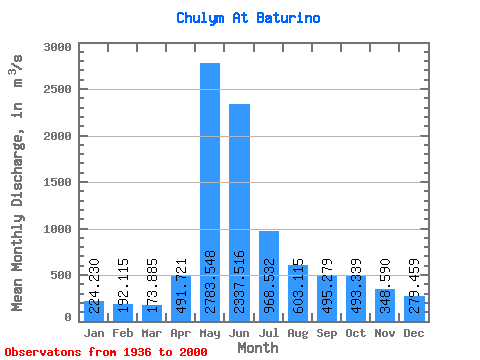
| Statistic | Jan | Feb | Mar | Apr | May | Jun | Jul | Aug | Sep | Oct | Nov | Dec | Annual |
|---|---|---|---|---|---|---|---|---|---|---|---|---|---|
| Mean | 224.23 | 192.12 | 173.88 | 491.72 | 2783.55 | 2337.52 | 968.53 | 603.12 | 495.28 | 493.34 | 348.59 | 279.46 | 782.29 |
| Standard Deviation | 55.64 | 43.95 | 34.11 | 295.93 | 549.16 | 928.04 | 317.88 | 179.49 | 142.76 | 173.69 | 116.93 | 68.00 | 151.89 |
| Min | 117.00 | 117.00 | 112.00 | 170.00 | 1730.00 | 735.00 | 455.00 | 331.00 | 280.00 | 261.00 | 196.00 | 170.00 | 460.58 |
| Max | 369.00 | 315.00 | 266.00 | 1470.00 | 4150.00 | 5670.00 | 1810.00 | 1170.00 | 885.00 | 966.00 | 682.00 | 454.00 | 1082.67 |
| Coefficient of Variation | 0.25 | 0.23 | 0.20 | 0.60 | 0.20 | 0.40 | 0.33 | 0.30 | 0.29 | 0.35 | 0.34 | 0.24 | 0.19 |
 Return to R-Arctic Net Home Page